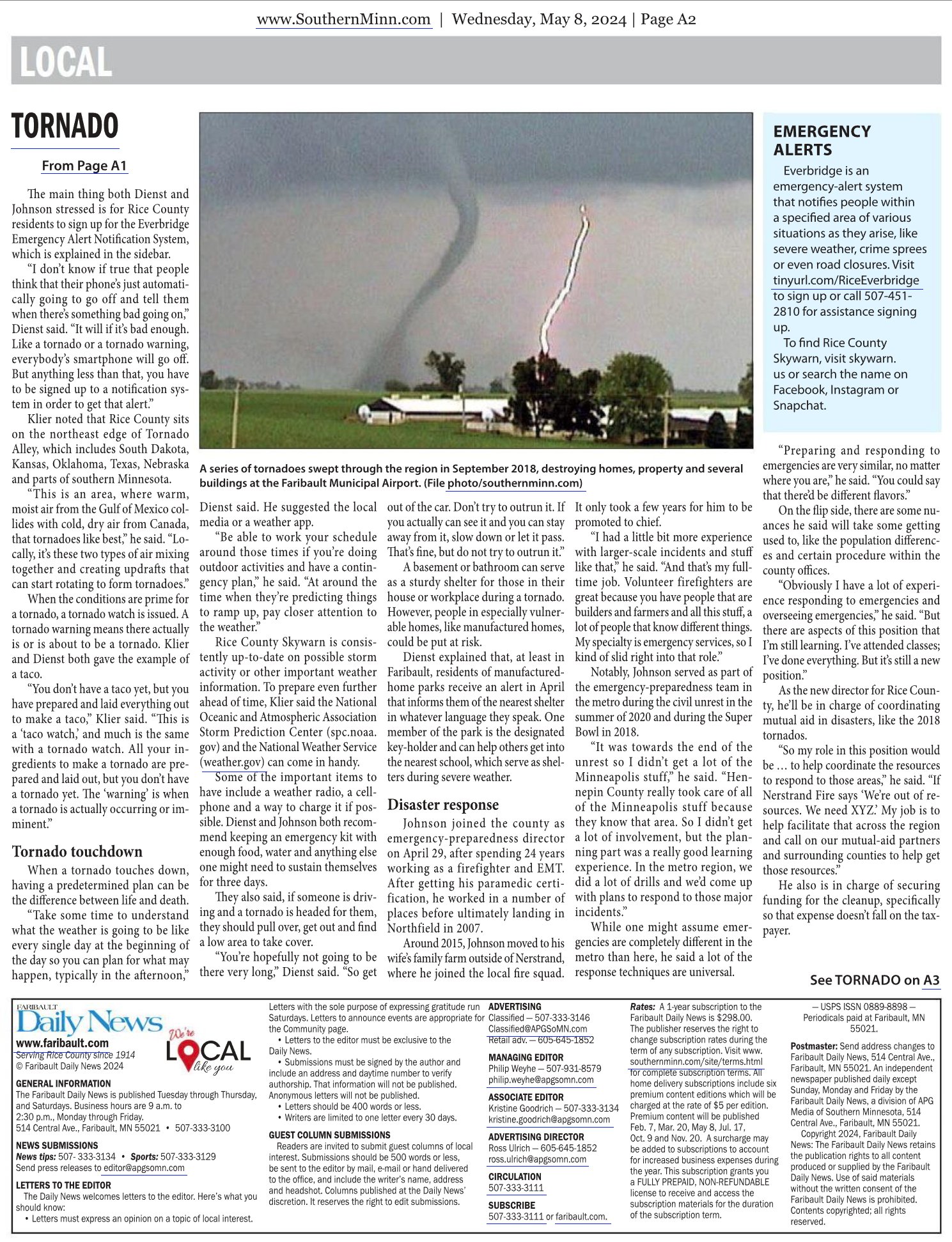
The Rice County Skywarn Streaming Channel is now live!

A fun side project I’ve been working on! Using the OBS Broadcaster, PowerShell, Batch Scripting, and a program that launches it all on a rotating time schedule!

Here is an example of how this all looks during a severe weather event:

Original Post:

The Rice County Skywarn Streaming Channel is now live!

Thanks for all your feedback regarding our Streaming Channel on Youtube! Hearing dozens of positive comments, and working out some kinks and adding some new functionality, it’s ready for full-time consumption!

https://youtube.com/@RiceCoSkywarn/live

This is YOUR local weather feed, perfect for the corner of your monitor, your tablet, your Google Home, or digital signage.

You’ll find:

– The latest Level 3 radar imagery (including velocity radar during time of severe weather) centered around Rice County, with storm reports plotted during severe weather events.
– Scrolling weather alerts and weather forecasts straight from the National Weather Service, tailored for Rice County.
– Current time, temperature, and rainfall storm totals and rain rate for Faribault displayed in the corner of the video.
– Upper Midwest GOES-East Satellite Loop with Precipitation Depiction.
– Local webcams showing current outdoor conditions (if you run a full-video webcam in Rice County and can offer an RTMP feed, we’d like to hear from you!)
– Skywarn Activation Status
– Pop-up alerts for extreme weather conditions such as Severe Thunderstorm Warnings, Tornado Warnings, and Blizzard Warnings.
– Of particular interest to spotters, the Day 1 convective and mesoscale outlooks, including possibilities of tornadoes, severe hail, and severe wind conditions.
– All over a bed of music, with old-school “Weather Channel”-style voice announcements (all mutable).

Besides a few national guys, NO ONE that we know of is doing this style of presentation, and we’d love to hear your input and ideas on how we can make this something you’ll enjoy on a daily basis. We appreciate your support!

Free training for new Skywarn storm spotters offered in person, virtually

Wow, we got a great article promoting the upcoming Skywarn training classes in the Faribault Daily News!

If you haven’t been re-certified in a while, now is your chance! Sogn Valley Skywarn is offering 2 in-person classes in Goodhue and Kenyon, and another virtual class. Read about them at Rice County Skywarn at https://skywarn.us/training

The full Daily News article is right here:

IF YOU GO

There are three training sessions planned by Sogn Valley Skywarn so far this year. All are always free, and participants who complete the course get a bumper sticker and guide book for storm spotters.

The first in-person session is from 6:30-9 p.m. March 24 at the Goodhue Fire Department, and the second in-person session is 9-11:30 a.m. March 29 at the Kenyon Fire Department. Registration is not required for the in-person sessions.

Registration is required for the virtual session, which is planned for 6:30-9 p.m. April 1. Signup and additional information is available at Sogn.us, and registration opens March 18.

Future dates could be added later. To stay aware of any future dates that might be added, go to Skywarn.us/training or visit the Rice County Skywarn page on Facebook. Go to www.meted.ucar.edu/education_training/course/23 for a virtual self-paced Skywarn class at any time.

Nice cloud rotation

Nice cloud rotation nearly right overhead tonight as a line of thunderstorms moved through!

It must have been an associated downburst that caused a LOT of mature tree damage in North Alexander park, and over by the King Mill Dam. Power was out in the northern part of Faribault for about 4 hours.

Faribault Woolen Mill Dam failure and subsequent patching

The City of Faribault, Minnesota – City Government Facebook wrote:

DAMAGE TO DAM: City of Faribault crews are currently working to stabilize flood-related erosion on the north side of the dam located next to the Faribault Mill, south of Slevin Park.

While the full extent of damages will not be entirely clear until water fully recedes, what can be seen has called for the need to stabilize the area and to prevent additional erosion.

The State has been notified, as is general practice in situations like this, and we’re encouraging everyone to avoid the area. Please do not proceed beyond barricades and/or police tape within Slevin Park.

There is no immediate public risk, and this erosion doesn’t appear to be as concerning as the Rapidan Dam situation, but with more rain in the forecast, the City – with help from partnering agencies – will continue monitoring the erosion.

Faribault, MN – Straight River Flooding Scene – The Next Day

Faribault Scene as of 7 a.m. 6/22 – 2nd Avenue Road Closure near the Fairgrounds, Cannon River Reservoir at Father Slevin Park, Straight River/Cannon River Reservoir at the Faribault Woolen Mills, Straight River at Fleckenstein Park, Urban flooding near the American Legion, River flowing over Union Pacific Railroad, Straight River at Teepee Tonka Park, Lowland flooding in Frogtown, 14th Street Trail Flooding, River near new floodwall at Waste Treatment Plant.

“Trapped by a Tornado”, KSTP’s Dave Dahl, April 26, 1996

We’ve learned a lot about tornadoes in severe weather in the past 28 years, and thus I’m posting this primarily as a “what never to do” video. There are several quotes and pieces of video in these clips that will give any modern storm chaser anxiety.

1:45 – Chasing on an Interstate highway, with no easy way to change directions 90 degrees if necessary. Seeking shelter from a tornado under a freeway overpass (never do this, please).

4:30 – More of the above.

6:00 – Even more of the above, with innocent video crew.

6:26 – Putting yourself in a situation where you need to lie flat in a ditch as a last ditch shelter.

6:48 – “Are we OK?” “Yes, we’re fine. I’ve been doing this for a long time. I’ve been doing this for 19 years watching this stuff. Never been this close.”

7:22 – “In a car, Get out, get away from the car, lay flat in the ditch, and that’s exactly what we did. And we stayed safe.”

The Tornado Siren

The “tornado siren”. Today, they are almost exclusively used to warn residents of a community, while they are outdoors, of hazardous weather events. But they weren’t always used for that.

During the cold war in the 1950s, sirens were acquired and installed by Civil Defense agencies throughout the country as part of Harry Truman’s Civil Defense Act. They were designed to warn people of a pending nuclear attack. In other words, if you heard the siren, you “ducked and covered” to protect yourself from the bright detonation flash and subsequent shock wave and fallout.

Later, in the early 1970s, they started to be used to alert residents of tornadoes and significant severe weather events as well.

The sirens use wireless technology to listen to their command to sound, and that command can come from several locations. The Rice/Steele Pearl Street dispatch center, Rice County Emergency Management offices at the law enforcement center, through mobile sources if necessary, and even manually as a last resort.

Here in Rice County, the sirens have been programmed to be able to sound in 10 separate quadrants. For example, if there is a threat near Faribault but not Morristown, Faribault sirens can sound, but not Morristown’s. Configuring the sirens in this way helps prevent confusion from having them sound when the threat is 10 or more miles away. Quadrants include Faribault, Northfield, Dundas, Nerstrand, Morristown, Warsaw, Millersburg, The Lakes, Veseli, and Lonsdale.

During today’s siren test, just like every 1st Wednesday of the month, you heard two distinct patterns. The first is what we call “alert mode”. That’s when the sirens spin up and produce a steady tone for a duration of time, and then spin back down. That mode gets used during severe weather. Then, the “attack mode” is tested. That is the classic “rise and fall” pattern that is commonly associated with a nuclear attack. Both are always tested, because you just never know.

Today, the severe weather alert sirens mean one thing. “Something urgent is going on. Get inside, and check your local radio, or online news source for more information.” That is their sole job. Always remember, THERE IS NEVER AN ALL CLEAR SIGNAL. Several factors such as cut electrical lines or mechanical failure could cause sirens to stop sounding, but the threat could still be very real.

With today’s efficient homes and commercial buildings, you will need a NOAA weather radio, weather app on your cell phone, or other way to alert you indoors instead of relying on the sirens. Despite that fact, the sirens still provide a useful and important service in Rice County.

Faribault severe storm as it comes in

A camera on a mast located on top of Jefferson Elementary School in Faribault, Minnesota pointing north captures the high wind event that caused damage throughout Southern Minnesota on September 20, 2018.
These were likely straight-line winds but the National Weather Service is still surveying the aftermath a week later.

A Tornado Just Hit Faribault.

The National Weather Service did its job tonight extraordinarily well. The Rice County Emergency Management and Dispatch sounded the alert sirens quickly. Our Skywarn social media posts went out immediately. These sources gave everybody in Rice County at least 15 if not 20 minutes of warning before the tornadoes came through.

Things are a mess around here. Bethany and I are OK, and our part of town had more tree damage than anything. This is the only damage I had.. a single piece of front fascia hanging down. It is absolutely nothing compared to several families dealing with losing their homes or businesses tonight.

West of Faribault is like a scene out of “Twister”. Corrugated metal hung up high in trees. Roofs of sheds laying in unharvested fields. Halves of silos gone completely. Trees through people’s living rooms. Horse trailers laying on their roof in the ditch. Recreational Vehicles tipped over like Hot Wheels at LeMieux’s Resort.

North of Faribault, not many hangars are left without major damage at our Airport. MetCon has structural damage to their building. The freeway, closed down because of vehicles tipped over and debris littering the roadway.

I’ve never seen this kind of devastation around the Faribault area. This is going to be talked about for a long time.

A Tour of the National Weather Service Office in Chanhassen

As Rice County Skywarn is a Weather-Ready Nation Ambassador, we got the opportunity to tour the National Weather Service in Chanhassen today! We talked to the meteorologists that forecast our weather and do such a good job updating the public over social media, without sensationalism. At 6 p.m., we watched a weather balloon launch with a radiosonde which measures temperature, humidity, and pressure all the way up to 100,000 feet. The data is used to create the models we use each day to predict the weather. The staff was so accommodating, informative, and polite! Afterwards, we stopped by Lion’s Tap for supper. It was a great afternoon away from the office!